Whittier
A rich, multi-cultural community, the Whittier neighborhood is 81 square blocks one mile south of downtown Minneapolis. Whittier is bounded by Franklin Avenue to the north, Interstate 35W to the east, Lyndale Avenue South to the west and Lake Street to the south. Approximately 14,000 people call this thriving community home.
The Washburn-Fair Oaks Mansion District is a historic district in the Whittier neighborhood centered on Washburn-Fair Oaks Park. The city of Minneapolis designated a district bordered by Franklin Avenue, Fourth Avenue South, 26th Street East, and First Avenue South. A smaller district, listed on the National Register of Historic Places, includes seven mansions along and near 22nd Street East including Pillsbury Castle, Eugene Merrill House, Gale Mansion, Charles S. Pillsbury House, John Crosby House, Caroline Crosby House, Luther Farrington House and George H. and Leonora Christian House
Whittier is also home to the world-renowned Minneapolis Institute of Art (Mia). Mia’s permanent collection has grown from 800 works of art to more than 89,000 objects. The collection includes world-famous works that embody the highest levels of artistic achievement, spanning from about 20,000 BCE and representing the world’s diverse cultures across six continents. The museum has seven curatorial areas: Asian Art; Arts of Africa & the Americas; Contemporary Art; Decorative Arts, Textiles & Sculpture;Paintings; Photography and New Media; and Prints and Drawings.
Mia is one of the largest arts educators in Minnesota. More than a half-million people visit the museum each year, and a hundred thousand more are reached through the museum’s Art Adventure program for elementary schoolchildren.
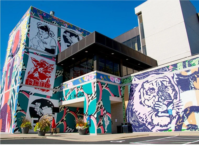
The Minneapolis College of Art and Design (MCAD), a private college specializing in the visual arts, also calls Whittier home. MCAD currently enrolls approximately 800 students.
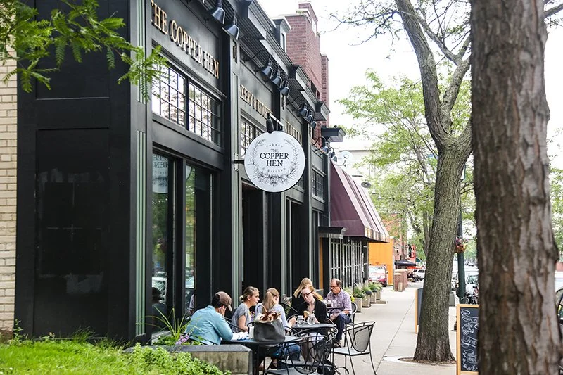
The neighborhood is most famous for the Nicollet Avenue commercial corridor, known as ‘Eat Street’ – home to thirteen blocks offering an array of independent and often family-run businesses including international restaurants, coffee shops, and markets. There’s everything from tacos and pho to schnitzel and jerk chicken, and most restaurants offer a drink menu to match their cuisines. In fact, many people describe themselves as living in the ‘Eat Street neighborhood’.
The multicultural dining options include great Vietnamese, Chinese, Middle Eastern, Somali, Caribbean, and American – and that is leaving out many other restaurants and amazing ethnic groceries.
-
![]()
Eat Street
-
![]()
Mia
-
![]()
MCAD
-
![]()
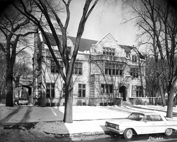
Washburn Fair Oaks Park


The History of Whittier
In 1849 at the age of 21, John T. Blaisdell moved from Maine and squatted on land just south of downtown Minneapolis. His brothers eventually came and together they lived in a log house which became Blaisdell School.
Following the 1851 Treaty of Traverse des Sioux which expropriated lands to the United States, Blaisdell developed the area south of Downtown Minneapolis into Blaisdell's Addition. For capital, he sold timber to the booming lumber industry and leased land for the Morrison Farm in the east, which the Morrisons eventually purchased.
From Blaisdell to Whittier
After the Blaisdell brothers returned from the Civil War in 1865, Minneapolis began growing in population again. Annexations in 1867 and 1883 turned Blaisdell's Addition into South Minneapolis.
The development in the area was spurred by the desire of prominent families to move away from the central business district and to build larger and more elegant homes along what was the edge of town. Much of the Morrison's farm was sold for this expansion.
In 1882, Blaisdell built his manor at Nicollet and 24th Street West. The family moved out of Blaisdell School. A year later, Blaisdell, Longfellow and Irving Schools across the southern prairie were annexed to the Minneapolis school system from Hennepin County. In naming tradition with the other schools, the board renamed the school Whittier after the 19th century poet and abolitionist, John Greenleaf Whittier. Like other areas of the city, families would soon call their neighborhoods after the primary school. Called the "millionaire pioneer of the city" by the New York Times, John T. Blaisdell died in 1898.
Washburn-Fair Oaks Mansion District
Dorilus Morrison who was the first mayor of Minneapolis and one of the first park commissioners selected the 9 acre area south of 24th Street to build his home, "Villa Rosa". Other entrepreneurs and businessmen soon followed, moving out of Downtown East to built their mansions in what is now referred to as the Washburn-Fair Oaks Mansion District. Development began around the early 1870s and continued through about 1930. The houses within the neighborhood represent a number of popular architectural revival styles.
Fair Oaks Park, at the center of this district, is named for a now-demolished mansion known as Fairoaks. Built in 1884 by E. Townsend Mix, Fairoaks was one of the grandest Twin Cities mansions of its era. The house itself had 40 rooms and sat on a lavishly landscape lot two square blocks in size. It was built for William D. Washburn, a lawyer who moved to Minneapolis in 1857 and amassed a fortune in the family milling business. Washburn lived in the house until his death in 1912, at which point he willed the mansion to the Minneapolis Park Board. The park board ultimately found the mansion too expensive to maintain, so it was demolished in 1924.
The Pillsbury family would built a series of 4 mansions on the north west corner of the park between 1883 and 1912 and made 22nd Street and Stevens Avenue their new compound.
Continued Expansion
Meanwhile, the southern end of Whittier grew as an agricultural and industrial job center with working-class housing along the Hastings and Dakota tracks of the Milwaukee Road rail line which rain along 29th Street trainsporting grain from southern Minnesota. Blaisdell Road became Blaisdell Avenue, extending past the neighborhood to the southern boundaries.
In 1878, the Minneapolis, Lyndale, and Lake Calhoun Railroad was incorporated by several Minneapolis and Columbus, Ohio businessmen, including Colonel William C. McCrory. The Lyndale Railway Co. started to construct a single, three foot gauge line to carry two steam engines enclosed in streetcar-like wooden bodies towing short trains along the track. The line was also known as “McCrory’s Motor Line,” after Colonel William C. McCrory, whose farm was called Lyndale.
Into the 20th century, Thomas Lowry and his partners assumed control of the insolvent McCrory's Motor Line. Whittier filled along Lowry's new Nicollet Ave. and 4th Ave. streetcar routes. The increasingly residential nature of southern Minneapolis brought contention with the Milwaukee Road as neighbors petitioned the City Council from 1905 to 1909 to alleviate the effects of the crossings which was blamed for several deaths. The Milwaukee Road offered a failed proposal to elevate the tracks and returned with a $1.3 million plan to depress the tracks and construct a dozen road bridges. After a legal battle with the businesses affected by loss of rail access, the project was upheld and completed in 1916.
Cultural Corridor
In 1883, twenty-five citizens of Minneapolis founded the Minneapolis Society of Fine Arts, committing them to bringing the arts into the life of their community. Dorilus Morrison’s “Villa Rosa" and surrounding land, located immediately south of the Fair Oaks Park, were donated to the City of Minneapolis in 1911 after his death by his son Clinton Morrison, with the condition that the land be used for the site of an art museum. Accordingly, the house was razed and the Society of Fine Arts built the Minneapolis Institute of Arts in 1915. Designed by the preeminent New York architectural firm McKim, Mead and White, a neoclassical landmark in the Twin Cities, the museum expanded in 1974 with an addition designed by Japanese architect Kenzo Tange and in 2006, the museum unveiled a new wing designed by architect Michael Graves.
MCAD was founded in 1886 by the trustees of the Minneapolis Society of Fine Arts and originally named the Minneapolis School of Fine Arts. Its inaugural class had an enrollment of 28 students, 26 of whom were women. In 1893, noted German-born painter and educator Robert Koehler moved from New York to Minnesota to become president of the school. Over the next ten years, he developed much of the curriculum that is known today as the art education field. In 1910, the School of Fine Arts changed its name to the Minneapolis School of Art to reflect the new emphasis on applied arts. In 1915, the Minneapolis School of Fine Arts moved to set up its classrooms and studios within the newly constructed Minneapolis Institute of Arts. In 1916, the school moved into its own nearby facilities in the new Julia Morrison Memorial Building, which was built with funds provided to the Minneapolis Society of Fine Arts by Dr. Angus Washburn Morrison and his sister, Ethel Morrison Van Derlip , as a memorial to their mother, Julia Kellogg Washburn Morrison , the wife of Clinton Morrison. Designed by prominent Minneapolis architect Edwin Hawley Hewitt, a former Minneapolis Society of Fine Arts president, the Morrison Building featured three large painting studios with skylights, administrative offices, workshops and an auditorium.
In 1970, the School was renamed the Minneapolis College of Art and Design to reflect the broadening of its fine arts and liberal arts curricula. By this time, with enrollment of nearly 600 students, the college had outgrown its facilities, and in 1974 expanded into a building designed by Pritzker Prize–winning modernist architect Kenzo Tange (1913–2005) as part of the new "arts complex" that included the Children's Theatre Company and a major addition to the Minneapolis Institute of Arts.
This block of land, which also holds the Children's Theatre, the Minneapolis College of Art and Design, and Target Park, is still officially known as Dorilus Morrison Park.
Post-War Decline
The neighborhood maintained a dense population and high rental occupancy up towards the city's population peak in the 1950s. The latter 20th century followed with other inner core neighborhoods as the postwar boom of the 1960s depleted Whittier's population. The routing of Interstate 35W was modified following city concerns over expensive land acquisition of apartments and mansions including the Minneapolis Institute of Arts. In November 1967, Interstate 35W was built around the neighborhood to spare the Mansion District which was later preserved as part of the Washburn-Fair Oaks Historic District.
Whittier experienced continuing decline as middle-class residents moved out. The demolition of Nicollet Ball Park in the Lyndale neighborhood led to retail failure on the neighborhood's south end. Abandoned buildings and adult bookstores prompted the city to establish the Nicollet/Lake Economic Development District in 1972.
In 1977 The Whittier Alliance was established to monitor the weakened community and rehabilitate housing. Whittier Alliance operated as a Community Development Corporation, developing housing for many years in order to sustain its operations in community outreach. The City attempted to bring about a citizen participation model to assist neighborhoods. It wasn’t until the State Legislature's assistance created the Neighborhood Revitalization Program in 1987 to formally address urban issues with funding. The city began designating official neighborhood boundaries at this time and Whittier was formalized.
Attempts were made to create a shopping corridor in the 1970s, however several years passed without activity as Target and Herberger's refused to build. K-Mart finally agreed to become a tenant on the grounds that the City close Nicollet Avenue at Lake Street, and the project was completed in 1978.
However a boon for the city, the closing accelerated the neighborhood's problems and Nicollet north of Lake Street was stifled of car traffic. Crime and prostitution became common. Neighbors who stayed had formed a neighborhood association in response to bitter protests over the K-Mart project.
Millennial rebirth
Several factors had sown seeds for Whittier's comeback from the post-war suburban flight. Nicollet Avenue had not suffered completely. An authentic German restaurant opened in 1965 at the corner of 26th and Nicollet, becoming the avenue's main restaurant anchor for decades. As Whittier gained a bohemian culture for its cheap housing, the Artist Quarter jazz club was opened in the 1970s on the adjoining corner establishing a music anchor in the region. During this time, Chinese and Vietnamese businesses began opening on Nicollet following the Vietnam War. The Hip SingTong branch headquarters at 2633 Nicollet may explain the presence. Mexican businesses, too, opened but later in the 1980s on as they became a growing proportion of the immigrant population.
Recognizing the street's potential, the Whittier Alliance and Business Association created a new branding initiative called ‘Eat Street’. It was completed in 1997 with a street scape reconstruction along the entire corridor.
The abandoned Milwaukee Road trench also gained renewed interest during this time for re-use as a rails to trails transportation corridor. The Midtown Community Works and Midtown Greenway Coalition formed and federal funds were acquired for redevelopment. The first phase of the new Midtown Greenway was built in 1999 and entirely finished in Minneapolis by 2005.
In the 2000s, after nearly two decades of private sector disinvestment, three major condominium projects were completed along Nicollet Avenue. In 2011 a major development came to the corner of 26th and Nicollet including a major indoor climbing facility and several new restaurants. In 2012, Whittier Alliance and the City of Minneapolis began working to move Kmart and restore Nicollet Avenue including a possible streetcar system.
Whittier Demographics
As of the 2020 census, 14,483 people live in Whittier. Census race groups consist of Caucasians (52.9%), Hispanics (Latinos) (15.6%), African Americans (19.3%), Native Americans (0.8%), Asian Americans (3.8%), and other (0.2%) (who are largely Somali in origin). About 82% of households rent. Whittier is the most populous neighborhood in Minneapolis, and second only in density to its neighbor Stevens Square. As reported single ancestry in the 2000 Census, the top five ancestries were German (1,780 people), Subsaharan African (1,070 people), Norwegian (870 people), Irish (830 people), and Somali (490 people).
Population Trend
1980 - 12,729
1990 - 13,0512
2000 - 15,247
2010 - 13,689
2020 -14,483